Isaias leaves 840,000 without power as rain risks persist
Isaias left about 840,000 customers without electricity across three states, PowerOutage.com reported, as forecasts pointed to further rainfall.
Atlas Newsdesk ·
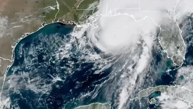
Isaias left about 840,000 customers without electricity across three states, PowerOutage.com reported, as forecasts pointed to further rainfall.
The outage estimate covered Florida, Alabama and Georgia on October 10, as Gulf Coast communities began examining storm damage. Forecasts indicated that the system would carry its rainfall threat inland through the weekend, extending the area exposed beyond the coast where it came ashore.
Isaias reached land near Destin, Florida, at 8:30 p.m., carrying maximum winds of 105 miles an hour, the US National Hurricane Center said. It arrived as a Category 2 hurricane before rapidly losing that classification and becoming a post-tropical cyclone, according to the center.
Destin landfall leaves regional outages
The reported electricity disruptions affected both households and businesses. The roughly 840,000 figure represents customer connections rather than an individual headcount, and the available estimate does not separate the totals for each state or provide a timetable for restoring service.
Transportation authorities shut roads and advised drivers to stay off local routes after flooding affected parts of Florida and Alabama. Storm surge had been forecast to reach nine feet; that figure was a projected coastal water hazard, not a confirmed measurement of what occurred.
The immediate recovery picture therefore involved both electricity access and road conditions. If additional rain keeps routes flooded, access to affected communities could remain constrained even after the strongest winds have passed; the material provides no confirmed reopening schedule for the closed roads.
Rain threat extends beyond Florida
Forecasters expected rainfall totals of up to eight inches across the affected region, with isolated locations potentially receiving 15 inches. Those higher local projections indicate an uneven rainfall threat rather than a uniform amount across Florida, Alabama and Georgia.
Tropical storm conditions were forecast to persist into Saturday morning. Forecasters expected the system to cross Alabama before progressing toward the Tennessee and Ohio valleys during the weekend, with heavy rainfall and possible tornadoes reaching as far north as the Carolinas.
The change to post-tropical status did not amount to a forecast that hazardous weather had ended. Authorities continued warning of rain from the remnants, making the storm’s inland track a separate concern from the coastal damage assessment.
Offshore production faces restart uncertainty
The supplied report also describes offshore companies removing platform personnel and repositioning drilling rigs before the storm approached. It reports a decline in Gulf of Mexico oil production but gives no volume, percentage change or operator-specific shutdown figures.
If offshore interruptions persist, reduced production could extend the disruption to energy supply; if facilities resume operations promptly, that effect could be shorter-lived. The report provides neither an oil-price reaction nor a restart schedule, leaving the duration and wider market consequences unresolved.
For coastal communities, the next practical milestones are electricity restoration and road reopening. Inland, the forecast rainfall totals, the system’s route and the possibility of tornadoes remain the more immediate indicators of where disruption could spread.